Support the Coalition simply by shopping at Amazon! Simply visit our unique link https://smile.amazon.com/ch/86-0735762 to configure your amazon account to benefit the Coalition.
With AmazonSmile, Amazon donates 0.5% of the price of eligible smile.amazon.com purchases to the Coalition.
[be sure to see update, below] To: Cochise County Highway Department
Misleading sign
When riding Ramsey Canyon Road from Hwy 92 to the Nature Conservancy there is a sign 350 feet before the multi-use path from Stafford Ln to the multi-use path on the South side of Ramsey Canyon Road leading to the parking lot at Brown Canyon Ranch.
When riding my bike up to the Nature Conservancy, many motor vehicle drivers will point to the multi-use path, indicating that I need to use the multi-use path. I have, also, talked to several residents whose only access to their homes is from Ramsey Canyon Road. They tell me this sign means that cyclist “must” use the multi-use path. I inform them about ARS 28-812 “Applicability of traffic laws to bicycle riders.” Furthermore, I know of no Arizona or County statute which makes this sign enforceable regarding a cyclist “must” use the multi-use path.
This sign is commonly misinterpreted and leads to irritation between cyclist and motor vehicle drivers.
The Coalition of Arizona Bicyclists have suggested the following recommendations. Reword the sign to include “MAY” that is, “MAY USE MULTI-USE PATH.” Or replace this sign with a sign specified by the MUTCD 9B.18 “Bicycle Warning and Combined Bicycle/Pedestrian Signs (W11-1 and W11-15).
We believe the justification for this change is that users of the path should be expected in the road crossing. Thus, the current sign should be replaced with W11-15 and W11-15P signs and keep the “350 feet” W16-2P sign.
Here’s what MUTCD says about that sign:
W11-15 sign
Section 9B.18 Bicycle Warning and Combined Bicycle/Pedestrian Signs (W11-1 and W11-15)
Support:
01 The Bicycle Warning (W11-1) sign (see Figure 9B-3) alerts the road user to unexpected entries into the roadway by bicyclists, and other crossing activities that might cause conflicts. These conflicts might be relatively confined or might occur randomly over a segment of roadway.
Option:
02 The combined Bicycle/Pedestrian (W11-15) sign (see Figure 9B-3) may be used where both bicyclists and pedestrians might be crossing the roadway, such as at an intersection with a shared-use path. A TRAIL X-ING (W11-15P) supplemental plaque (see Figure 9B-3) may be mounted below the W11-15 sign.
03 A supplemental plaque with the legend AHEAD or XX FEET may be used with the Bicycle Warning or combined Bicycle/Pedestrian sign.
Guidance:
04 If used in advance of a specific crossing point, the Bicycle Warning or combined Bicycle/Pedestrian sign should be placed at a distance in advance of the crossing location that conforms with the guidance given in Table 2C-4.
Standard:
05 Bicycle Warning and combined Bicycle/Pedestrian signs, when used at the location of the crossing, shall be supplemented with a diagonal downward pointing arrow (W16-7P) plaque (see Figure 9B-3) to show the location of the crossing.
Option:
06 A fluorescent yellow-green background color with a black legend and border may be used for Bicycle Warning and combined Bicycle/Pedestrian signs and supplemental plaques.
Guidance:
07 When the fluorescent yellow-green background color is used, a systematic approach featuring one background color within a zone or area should be used. The mixing of standard yellow and fluorescent yellow-green backgrounds within a zone or area should be avoided.
Thank you for taking our concerns under consideration.
Thomas Armstrong League of American Bicyclist League Cycling Instructor #3337 International Mountain Bicycling Association (IMBA) Coalition of Arizona Bicyclists Board Member
UPDATE December 2018:
The old sign (left) was replaced with a standard “Trail X-ing” warning sign (right) around December 2018. The old sign could be misconstrued to imply bicyclists aren’t permitted on the roadway; as this is not the case, the warning sign is more appropriate. Thank you Cochise County Highway Department!
As you know, College Avenue is a major north/south bicycling corridor, especially because of the presence of the Arizona State University campus, and a dedicated shared-use bike & pedestrian bridge over US60. The area between US60 and ASU campus was improved with traffic calming several years ago and remains a very safe road for all users.
It has come to our attention that the City of Tempe is considering various treatments along College Ave south of US60; an area that is primarily residential and currently has no bicycling-specific striping or pavement markings.
When selecting please refrain from placing designated bike lanes withing the door zone of parked vehicles; The two “Orange” Alternatives; Bike Lanes with a parking lane show such treatment with the right-hand edge of the bike lane only 8 feet from the curb which places most of the width of the bike lane within a hazard-zone. This places bicyclists in the uncomfortable position of need to ride away from door zones to remain safe and inevitably suffer harassment, or worse, from motorists.
You may wish to consult NCHRP 766Recommended Bicycle Lane Widths for Various Roadway Characteristics which documents that the open door width of most private passenger vehicles extends about 11 feet from the curb (and of course, vehicles can be wider still; and drivers often park their vehicles further from the curb). Bicycle facilities should be designed to keep cyclists out of this hazard zone. More information about placing Bike Lanes adjacent to parking can be found here.
Regards,
Ed Beighe President
Coalition of Arizona Bicyclists
This year, the annual meeting will be held via tele-conference.
A business meeting and election of open board of directors seats will be held.
Tuesday, November 20, 2018 at 6:30PM Arizona Time.
Members in good standing who wish to attend/listen/vote please contact cazbike@cazbike.org no later than 11/16 to obtain the phone in details. Not a member? Click here to join.
Nominations, or self-nominations for the Board of Directors are still open, and as always we’re looking for volunteers in any capacity.
Minutes of 2018 Annual Meeting (approved at 12/18/2018 board meeting)
The meeting was held telephonically November 20, 2018 beginning at 6:45PM, present at the meeting were directors: Tom Armstrong, Bob Beane, Ed Beighe, Bob Jenson, Sharon Matt, Eric Post, Lloyd Thomas. (Gail Hildebrant was absent).
Also present were Peter Mather, and Rich Leever, and Jeff Caslake
Treasurer’s Report (via email)
As of October 31st, the balances in the Coalition’s Wells Fargo Accounts are as follows:
Checking $661.32
Savings $515.85
High Yield $32,427.21
Total Balance: $33,594.38
We currently have 8 directors; (with a maximum of 15 per bylaws). Directors serve two-year terms
2 do not expire until next year, and 6 expire this year, as noted in the list below the current board is:
Tom Armstrong (2019)
Bob Beane (2018)
Ed Beighe (2018)
Gail Hildebrant (2018)
Bob Jenson (2018)
Sharon Matt (2018)
Eric Post (2019)
Lloyd Thomas (2018)
Eric Post made a motion to nominate the six directors with terms expiring in 2018 — Bob Beane, Ed Beighe, Gail Hildebrant, Bob Jenson, Sharon Matt, Lloyd Thomas — to new 2 year terms; Tom Armstrong 2nd the motion. A voice vote was taken and all present voted affirmative, and none negative.
Next, Ed Beighe made a motion to nominate Rich Leever for a (new) 2 year term to board; Bob Beane 2nd the motion. A voice vote was taken and all present voted affirmative, and none negative.
The new board now consists of 9 members, with terms expiring as noted below. A quorum now is at least 5 board members present:
Tom Armstrong (2019)
Bob Beane (2020)
Ed Beighe (2020)
Gail Hildebrant (2020)
Bob Jenson (2020)
Rich Leever (2020)
Sharon Matt (2020)
Eric Post (2019)
Lloyd Thomas (2020)
Officer Elections
The newly-constituted board held officer elections for one-year term. Lloyd Thomas made a motion to nominate the current slate of officers, as below, Eric Post 2nd the motion. No other nominations were made. A voice vote was taken and all directors present voted affirmative, and none negative.
President: Ed Beighe
Vice President Operations: Bob Jenson
Vice President Special Projects: Bob Beane
Treasurer: Gail Hildebrant
Secretary: Sharon Matt
The business meeting concluded at approximately 7:15PM and informal discussions followed.
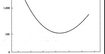
In a landmark study of speed and crashes involving 10,000 drivers on 600 miles (970 kilometers) of rural highways, Solomon (1964) found a relationship between vehicle speed and crash incidence that is illustrated by a U–shaped curve. Crash rates were lowest for travel speeds near the mean speed of traffic, and increased with greater deviations above and below the mean.
however:
Excluding these (vehicles entering or vehicles slowing to leave the roadway) crashes from the analysis greatly attenuated the factors that created the U–shaped curve characteristic of the earlier studies. Without vehicles slowing to turn, or turning across traffic, the investigators found the risk of traveling much slower than average was much less pronounced. Crash risk was greatest for vehicles traveling more than two standard deviation above the mean speed.
It’s also wasn’t clear to me how or if any of this has to do with urban or suburban streets — where by definition, traffic starts and stops for a variety of necessary reasons.
There was an article published Jan 2015 in fiverthirtyeightdiscussing these concepts as well as some background of NYC’s move to make the default city-wide speed limit 25mph, down from 30mph.
Traffic Safety and Human Behavior There’s a updated 2017 edition of Traffic Safety and Human Behavior: Second Edition, edited by David Shinar where, of course, the Solomons’ curve issue is dealt with; from the chapter Speed and Safety:
… Solomon (1964) found that drivers who drove either significantly above or below the prevailing average traffic speed were more likely to have crashes than drivers who drove at speeds close to the average. However, most crash-involved slow drivers were turning at the time of the crash; and when turning vehicles were removed from the analysis only those driving at speeds significantly above the traffic speed remained over-invovled in crashes (Fildes and Lee, 1993)
He later goes into a finely detailed review of Solomon (rural only; data from the 1950’s, etc) as well as reviewing a plethora of research published in the decades since that attempts to correct Solomon’s short-comings.
Shintar also notes that speed, when self-reported by (presumably speeding) drivers involved in a crash tend to be below actual speeds because of “Stannard’s Law” which states “drivers tend to explain their traffic accidents by reporting circumstances of lowest culpability compatible with credibility (Aronoff, 1971)”
In July 2017, the NTSB (National Transportation Safety Board) released a major study: SS1701 Reducing Speeding-Related Crashes Involving Passenger Vehicles. In discussing Solomon 1964, it echo’s Shintar “These studies generally provided consistent evidence that driving faster than the surrounding traffic increased crash involvement rates; the evidence was less conclusive with respect to driving slower than the surrounding traffic (Aarts and van Schagen 2006)”. The report goes on to question the concept of setting speed limits at the 85th percentile on roads that are not freeways.
Speed and Crash Risk
Speed and Crash Risk, irtad (part of OECD) issued a 2018 report on the issue echoing the same sentiments about mis-use of Solomon’s work.
Many of you may not know it, but volunteers from the Coalition, led by Peter Mather, endeavor to deliver and keep stocked all Maricopa County bike shops with MAG (Maricopa Association of Gov’ts) Bikeways Maps. This is a huge task.
Peter needs your help — in particularly he is seeking new volunteers to deliver maps to shops in particular areas; you would be assigned 8-10 shops closeby your residence; or perhaps by your work. It’s best if the volunteer can go to the MAG ( office in the Valley Metro building in downtown Phoenix to pick up the boxes of maps, but if not we may be able to make alternate arrangements. The volunteer with then visit the shops about once every two months to restock them.
At this time, Peter is looking for a volunteer(s) to cover shops in North Phoenix / Carefree area, for example:
Hundreds of events are scheduled worldwide on May 16, 2018 in the annual Ride of Silence. (always the third Wednesday in May).
Details of other Arizona rides as they are announced (check back often) can be found at rideofsilence.org…. events are currently planned around Arizona for Flagstaff, Cottonwood , Santa Cruz Valley / Green Valley, Prescott, and Tucson.
A bill to outlaw texting while driving passed the Senate Transportation Committee unanimously yesterday, signaling a possible shift. Similar bills have been introduced in the Arizona legislature, and died, for over a decade. Several possible explanatinos for the shift were explored by Arizona Republic columnist Roberts: Is Arizona ready (finally) to ban texting while driving?
Just before casting his vote, committee Chairman Rep. Bob Worsley, R-Mesa apologized to the public for taking so long to move the bill forward. “Sometimes it just seems like our political ideology gets in the way of common sense,” he said. — AZ Republic 2/7/2018


 Thomas Armstrong


 Normally cited by those wishing slow-moving vehicles should never use any roadway, even though it is perfectly legal, is the Solomon u-shaped curve, the claim is typically something to the effect of it’s safest when all traffic travels at the same speed; ergo a vehicle must never go slower than the “speed of traffic” and must not be on the roadway in the first place. A corollary to this line of thinking is the belief that posted speed limits are really minimum speed limits.
 It’s a great opportunity to help you your fellow cyclists (and would-be cyclists!) and get to know and interact with the bike-shop community as well.

