Your Opportunity to Comment On the Manual on Uniform Traffic Control Devices

The Manual on Uniform Traffic Control Devices (MUTCD) is up for review and comments are being accepted through May 14, 2021. As stated in the Federal Register, the MUTCD is “recognized as the national standard for traffic control devices used on all public roads.” The standards in this manual include traffic controls, signs, and roadway markings. The MUTCD has historically focused on moving motor vehicle traffic quickly, with little regard for the safety of non-motorized road users.

This is an opportunity for you to recommend changes to the MUTCD that are more inclusive for people that ride bicycles on our roadways. We created a template that you can use as a guide in providing your own comment to the Federal Highway Administration (FWHA). Please copy this letter, make any changes you feel are appropriate, and post to the Federal Register Comment Site listed below.


To: Stephanie Pollack
Acting Administrator
Federal Highway Administration

As a member/supporter of the Coalition of Arizona Bicyclists, I request that the Manual on Uniform Traffic Control Devices (MUTCD) be revised to better support non-motorized road users. Changes should be made to lower speeds, improve bicycle facilities, and treat all road users equally. These changes can create a shift that will reduce traffic deaths and injuries, and make it easier for people that are not in cars to move around their communities.

The MUCTD currently prioritizes the fast movement of motorized traffic without regard to the safety of other road users. This should change. Specific changes that should be made include:

      • Stop using the 85th percentile when setting speed limits. There are more current methodologies that better account for the needs of non-motorized road users.
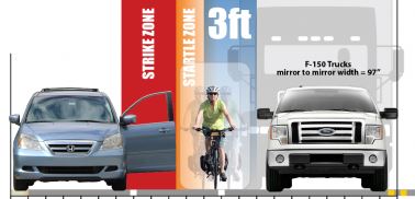
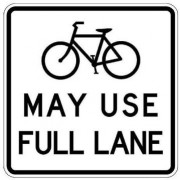
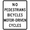
      • Review bicycle related signage and road marking. Consider making optional signs and road marking required, and allow bicycle rider specific signs.
      • Stop using the number of people killed or injured as the measurement that ‘warrants’ changes to make a roadway or intersection safer.
      • Incorporate the criteria from the FHWA’s Bikeway Section Guide into the MUTCD so that selection of the appropriate bicycle facility for a roadway is based on traffic speed and volume.

Bicycle ridership has been on the increase in the United States, so please consider people on bicycles and other non-motorized road users in the review and changes to the Manual Uniform Traffic Control Devices.

Sincerely, [your name here]


Please note that all comments become public information. So be aware of what you write, and decide for yourself what personally identifying information you include.

Federal Register Comment Site: https://www.federalregister.gov/documents/2021/02/02/2021-01440/national-standards-for-traffic-control-devices-the-manual-on-uniform-traffic-control-devices-for#open-comment

Further Resources:

MUTCD Official Site https://mutcd.info/

MUTCD Bicycle Page: https://mutcd.fhwa.dot.gov/pdfs/2009/part9.pdf

Toole Design posted a table that contains specific wording changes and location of those changes in the revised MUTCD. This document can be searched for specific bicycle references.  https://www.regulations.gov/comment/FHWA-2020-0001-0853

Learn more about the MUTCD at this recorded webinar: The ’Notorious’ MUTCD – Why Fixing a Federal Manual is Critical to Safety, Equity and Climate https://americawalks.org/the-notorious-mutcd-webinar-recording/

Shoulder access to South Mountain Freeway

R5-10a

ADOT recently completed and opened the South Mountain Freeway in late 2019; which was heralded — rightly so — as a great accomplishment that will provide a much needed connection between the communities of Ahwatukee and Laveen, or more broadly a direct connection between South East and West Valley, bringing for example enhanced employment opportunities. This publicly funded project (funded mostly from sales taxes [4] ), at present, and by default prohibits non-motorized users; this leaves members of the public who choose to or must travel by bicycle excluded.

The Coalition of Arizona Bicyclists (CAZBike) in September 2016 requested that ADOT evaluate access to a very small portion, between two adjacent traffic interchanges, pointing out lack of frontage roads or other suitable routes:

9/29/2016 “(CAZBike) formally request(s) a response from ADOT on allowing bicyclists to use paved shoulders to connect between the western end of the Ahwatukee Foothills and 51st Avenue [since that was written, the since-added Vee Quiva Way would now be the most appropriate western terminus, and 17th Avenue would be the logical eastern terminus because that would coincide with the western end of shared-use path ADOT has since constructed]

And partially reiterates 11/18/2016 “What is the status of my request … and my request that this be done formally with documented response? I want this to all be public record so I want to do it the right way”

We received the following response 4/20/2020 [1], this would be over three years after the request was made. Unfortunately, the response fails to take into account the policy referenced [2], no traffic study of alternate routes was mentioned, and the decision appears arbitrary. The referenced policy makes no mention of ‘metro’ (or ‘urban’,  or ‘rural)’. The reference to Table 1030-A as constituting documentation is specious — the route of the South Mountain Freeway portion of SR202 was not even sited for many years, possibly decades, after SR202 was added to that table. The policy demands a study, and that “Each case shall be judged on its own” yet it wasn’t.

We continue to request that ADOT prepare a traffic study of the area in question, and only then make a decision informed by those particular facts. Prohibiting bicyclists from using the shoulder may in fact be more dangerous; without an objective traffic study we cannot know. ADOT will need to assign the task to an engineer who is skilled in bicycle traffic; and should be familiar with the ADOT reference documentation[6], below.


In addition, it should be investigated how such matters get handled, as the process was frustrating, needlessly protracted, and at times even dishonest and non-professional. The personnel we were instructed to deal with which included at different times Mike Sanders (the bike/ped coordinator at the time the request was made), then on 6/8/2017 (per our meeting with Director Halikowski) Eric Gudino, and as of 12/6/2019 Mr. Gudino informed us our contact would be Donna Lewandowski (the current bike/ped coordinator). The few answers we received over the years were a mixture of: incomplete, lacking documentation, diversionary, falsehoods. See timeline[3]. It is quite clear after viewing some ADOT-internal emails dated 11/22 and 11/23/2020 at that time ADOT engineers were planning a traffic study, consistent with policy. Just after, all activity suddenly and secretly ceased; and we were never informed. We met in-person with numerous ADOT managers 6/8/2017, including Dallas Hammit, when the issue was raised by CAZBike, no one present had anything to say.

ADOT is a public agency and as such has a duty to operate openly and transparently.

Continue reading Shoulder access to South Mountain Freeway

Misleading sign on Ramsey Canyon Road has been corrected

[be sure to see update, below]
To: Cochise County Highway Department

Misleading sign

When riding Ramsey Canyon Road from Hwy 92 to the Nature Conservancy there is a sign 350 feet before the multi-use path from Stafford Ln to the multi-use path on the South side of Ramsey Canyon Road leading to the parking lot at Brown Canyon Ranch.

When riding my bike up to the Nature Conservancy, many motor vehicle drivers will point to the multi-use path, indicating that I need to use the multi-use path. I have, also, talked to several residents whose only access to their homes is from Ramsey Canyon Road. They tell me this sign means that cyclist “must” use the multi-use path. I inform them about ARS 28-812 “Applicability of traffic laws to bicycle riders.” Furthermore, I know of no Arizona or County statute which makes this sign enforceable regarding a cyclist “must” use the multi-use path.

This sign is commonly misinterpreted and leads to irritation between cyclist and motor vehicle drivers.

The Coalition of Arizona Bicyclists have suggested the following recommendations. Reword the sign to include “MAY” that is, “MAY USE MULTI-USE PATH.” Or replace this sign with a sign specified by the MUTCD 9B.18 “Bicycle Warning and Combined Bicycle/Pedestrian Signs (W11-1 and W11-15).

We believe the justification for this change is that users of the path should be expected in the road crossing. Thus, the current sign should be replaced with W11-15 and W11-15P signs and keep the “350 feet” W16-2P sign.

Here’s what MUTCD says about that sign:

W11-15 sign

Section 9B.18 Bicycle Warning and Combined Bicycle/Pedestrian Signs (W11-1 and W11-15)

Support:

01 The Bicycle Warning (W11-1) sign (see Figure 9B-3) alerts the road user to unexpected entries into the roadway by bicyclists, and other crossing activities that might cause conflicts. These conflicts might be relatively confined or might occur randomly over a segment of roadway.

Option:

02 The combined Bicycle/Pedestrian (W11-15) sign (see Figure 9B-3) may be used where both bicyclists and pedestrians might be crossing the roadway, such as at an intersection with a shared-use path. A TRAIL X-ING (W11-15P) supplemental plaque (see Figure 9B-3) may be mounted below the W11-15 sign.

03 A supplemental plaque with the legend AHEAD or XX FEET may be used with the Bicycle Warning or combined Bicycle/Pedestrian sign.

Guidance:

04 If used in advance of a specific crossing point, the Bicycle Warning or combined Bicycle/Pedestrian sign should be placed at a distance in advance of the crossing location that conforms with the guidance given in Table 2C-4.

Standard:

05 Bicycle Warning and combined Bicycle/Pedestrian signs, when used at the location of the crossing, shall be supplemented with a diagonal downward pointing arrow (W16-7P) plaque (see Figure 9B-3) to show the location of the crossing.

Option:

06 A fluorescent yellow-green background color with a black legend and border may be used for Bicycle Warning and combined Bicycle/Pedestrian signs and supplemental plaques.

Guidance:

07 When the fluorescent yellow-green background color is used, a systematic approach featuring one background color within a zone or area should be used. The mixing of standard yellow and fluorescent yellow-green backgrounds within a zone or area should be avoided.

Thank you for taking our concerns under consideration.

Thomas Armstrong
League of American Bicyclist
League Cycling Instructor #3337
International Mountain Bicycling Association (IMBA)
Coalition of Arizona Bicyclists Board Member


UPDATE December 2018:

The old sign (left) was replaced with a standard “Trail X-ing” warning sign (right) around December 2018. The old sign could be misconstrued to imply bicyclists aren’t permitted on the roadway; as this is not the case, the warning sign is more appropriate. Thank you Cochise County Highway Department!

Tempe: College Ave bike treatments S of US60

To: Chase_walman@tempe.gov

College Avenue “Orange” alternative

As you know, College Avenue is a major north/south bicycling corridor, especially because of the presence of the Arizona State University campus, and a dedicated shared-use bike & pedestrian bridge over US60. The area between US60 and ASU campus was improved with traffic calming several years ago and remains a very safe road for all users.

It has come to our attention that the City of Tempe is considering various treatments along College Ave south of US60; an area that is primarily residential and currently has no bicycling-specific striping or pavement markings.

When selecting please refrain from placing designated bike lanes withing the door zone of parked vehicles; The two “Orange” Alternatives; Bike Lanes with a parking lane show such treatment with the right-hand edge of the bike lane only 8 feet from the curb which places most of the width of the bike lane within a hazard-zone. This places bicyclists in the uncomfortable position of need to ride away from door zones to remain safe and inevitably suffer harassment, or worse, from motorists.

You may wish to consult  NCHRP 766 Recommended Bicycle Lane Widths for Various Roadway Characteristics which documents that the open door width of  most private passenger vehicles extends about 11 feet from the curb (and of course, vehicles can be wider still; and drivers often park their vehicles further from the curb). Bicycle facilities should be designed to keep cyclists out of this hazard zone. More information about placing Bike Lanes adjacent to parking can be found here.


Regards,

Ed Beighe
President
Coalition of Arizona Bicyclists


The presentation made by city staff can be found in the 9/11/2018 meeting packet for the Tempe Transportation Commission, item 7 of the lengthy document (seach down for “College Ave”)


More information on the projects, see the City’s page College Avenue BikeIt Project. There is an online comment form that can be submitted there (see Click here to comment online from Oct. 27 to Nov. 12, 2018)


ADOT to build “high-speed” path along 202 Freeway

[UPDATE to this article which was initially written in 2017, see comments below; path is nearing completion as we approach Summer of 2020]

Having ADOT agree to construct a 20′ wide “high speed” bike facility that will be six miles long with less than five street crossings (first of its kind in AZ, and maybe the whole country) could be part of a major sea change in Arizona. This is on par with the Hwy 179 re-construction between Sedona and the Village of Oak Creek in north central AZ. Both projects are “ground-breaking” departures from ADOTs past behavior, even though the ultimate “maintenance owner” of the project will be a locality and/or groups
of bicycle-supporting entities. Bike lanes will also be added to the Chandler Boulevard extension as a result of meetings with the same group, which includes City of Phoenix.

Everyone listed as a signer in the attached letter had a valuable role in making this happen. Bicycling community kudos go especially to Joe Struttmann, who was what I like to call “the pit-bull on the pant leg” with respect to ADOT. We will continue to push ADOT to become more bicycle-friendly (watch for updates on this and other issues within the next couple of months). Bicyclists can be heard…we have to offer constructive options to ADOT, and speak from a base of support. Bicyclists who want better, more safe riding conditions need to join the efforts and speak up.
They need to join groups such as the Pecos Action Group, Coalition of Arizona Bicyclists, Arizona Bicycling Club, Living Streets Alliance
(Tucson), GABA (Tucson), CASAZ (southern AZ), Verde Valley Cyclists Coalition and/or other advocacy groups and ask for and be present in meetings that impact our bicycling environment (infrastructure, education, allocation of transportation funding, etc.).

Please read and share the attached letter to show what is possible when people work together in their community.

Also, if you can, please join us at the 2017 Arizona Bicycling Summit this Friday 3/31/2017 at the Mesa Convention Center.

Bob Beane
President, Coalition of Arizona Bicyclists


Dear Residents,

On March 22nd , we had a very productive and successful meeting with ADOT regarding the construction of the 202 Freeway. The meeting was led by Arizona State Representative Jill Norgaard, and attended by Arizona State Senator Sean Bowie, Phoenix Councilman Sal DiCiccio, Ahwatukee Village Planning Committee Chair Chad Blostone, Foothills HOA President Bill Fautsch, Club West Vice President Mike Hinz, Pecos Action Group President Joe Struttman, Coalition of Arizona Bicyclists President Bob Beane, high level staff from the City of Phoenix, ADOT Director John Halikowski and his staff.

This was a collective effort by all of us, regardless of party lines, to work together to solve significant issues facing our community. The majority of the issues below were resolved at this meeting.

Here are some of the items discussed:

1) Chandler Blvd Extension– the major concern was to design a safe and usable roadway that could accommodate vehicular traffic, cycling and pedestrians. As you may recall, this was originally designed with just two lanes. The roadway is now under construction with a much safer design which includes a center turn lane and two approximate five-foot (5 ft) bicycle lanes. Construction has started and is estimated to be completed this summer.

2) Request to extend traffic study to Desert Foothills/Chandler Blvd and Ray Rd/Chandler Blvd, including the intersection of Ray and Chandler. With the planned 202 footprint, it is critical for Phoenix to have a true analysis of the impact of traffic on our communities. The City has already begun this study and is reaching out to community leaders for input.

3) Shared Use Path running along the southern side of the 202- The final design will be completed shortly with direction to make it compatible with high speed bicycle use. This facility will be the first of its kind in the nation and is expected to bring cycling enthusiast from all around the state to our community. This started as an idea and has now transformed into what could be the first cycling park of this kind in the nation thanks to the collaboration of this group.

4) 32nd street emergency access and future intersection options- ADOT has agreed to creat an emergency access point for our schools in this immediate area.

5) Explore alternative water sources and water infrastructure for Ahwatukee- ADOT has agreed to bring a sleeve from the southern area of the freeway to the north side to help with a water solution. This should solve the water issue for Foothills, and creates a partial solution for Club West.

We are all committed to continue working together for a solution to completely solve this problem and we are happy to have ADOT’s support thus far.

As we continue the progress, we will keep you updated through a series of these open letters.

Sincerely,

Sal DiCiccio / Phoenix City Council District 6

Jill Norgaard / Arizona State Representative District 18

Sean Bowie / Arizona State Senator District 18

Chad Blostone / Ahwatukee Village Planning, Committee Chairman

Bill Fautsch / Foothills HOA President

Mike Hinz / Club West Vice President

Joe Struttman / Pecos Action Group President

Bob Beane / Coalition of Arizona Bicyclists President

Funding

Funding for the path construction has not been broken out; but the entire freeway project was funded primarily from sales taxes…

According to info posted on the FHWA website the Loop 202 / South Mountain Freeway cost nearly $2Billion (excluding financing costs), and has the following funding sources. Note that the largest funding source is a SALES TAX. ($702M, RARF) and and the 2nd largest source are bonds which will be paid off with SALES TAXES ($435M, RARF bond).

Cost $1.837 billion (YOE, not including financing costs)
Funding Sources Federal funds – $493.8 million
State Highway User Revenue Fund Bonds – $205.9 million
Regional Area Road Fund (1/2-cent sales tax) – $702.4 million
Regional Area Road Fund Bonds – $435.3 million

             retrieved from https://www.fhwa.dot.gov/ipd/project_profiles/az_loop_202.aspx

Beane: ADOT needs to broaden its concept of transportation

Commentary by Coalition President Bob Beane, regarding the South Mountain Freeway (the last remaining unbuilt portion of Loop 202), set to begin construction later this year…

Beane: ADOT needs to broaden its concept of transportation

Posted: Tuesday, January 12, 2016 4:56 pm
Commentary by Bob Beane Special to AFN (Ahwatukee Foothill News)

Roughly six years ago, a locally based Federal Highway Administration official assured me (verbally, of course) that ADOT would be required to accommodate the bicycling community (transportation-oriented and recreational/fitness) if/when the 202 “Pecos” freeway was built going around South Mountain to the west. The “accommodation” requested was/is a road or pathway to connect to 51st Avenue from the western edge of the Ahwatukee Foothills.

Initially, ADOT was gathering related input from bicyclists. But, somewhere along the way, the ”accommodation” seems to have evaporated. Possibly, it coincided with the inability to achieve an alignment that didn’t require costly blasting through two ridges at the west end of South Mountain. So, within a $1.75 billion project with four freeway lanes in each direction (really?), cost savings need to come from NOT providing for any means for bicyclists, pedestrians or any other non-vehicular mode users to be able to cover roughly four miles (or less) between the western edge of the Ahwatukee Foothills and 51st Avenue.

As it stands today, no accommodation is planned that I know of or can discern from publicly released plans. There are no connecting frontage roads, and there are no plans for a bike path in the right of way (as have been built in places such as Colorado or Utah).
However, a concerned group of bicycling advocates and some community leaders from Phoenix, Chandler and Tempe are seeking to at least get ADOT to design in enough space within the right of way to allow a bike path to be constructed. I can’t speak for everyone in the group, but the consensus seems to be that having this connectivity in place would be an equitable and extremely positive non-vehicular transportation connection and recreational amenity that would enhance the neighboring communities.
Setting aside the issue of whether this freeway project is truly needed, it seems to many that ADOT still stands for “Arizona Department of Trucks (and Cars)” and that ADOT remains miles away from being a true transportation department that has a broader vision of its role and potential in contributing a multi-modal environment to the communities in which it operates. ADOT leadership, to date, seems to lack any vision of contributing to the overall health and community environment in a way that other DOTs have embraced for years.
A fraction of a fraction of the cost of this massive project could not only allocate space within the design, but fund a bike path for at least four miles, or so. But, that’s, sadly, not in the plans…yet. As I mentioned, there is a significant constituency that is asking for ADOT to incorporate non-vehicular connectivity into the 202 freeway plans. We are hopeful that ADOT can take a significant community-oriented step forward by approaching this request with a “how can we help make this happen” attitude, rather than the perceived car-centric, liability and cost-based blinders that seem to have guided past decision-making.
Ahwatukee resident Bob Beane is president of the Coalition of Arizona Bicyclists.

PDF of print edition: BeaneAFN_Guest_Commentary


More about the South Mountain Freeway

Official ADOT homepage for SMF. The South Mountain Freeway is the last piece to complete the Loop 202 and Loop 101 freeway system. The freeway is a part of the Regional Transportation Plan funding passed by Maricopa County voters in 2004 by Proposition 400, a 0.5% sales tax, proceeds of which predominantly fund freeway construction.